Congratulations to the Mars Society for reaching its kickstarter goal for MarsVR.

The long-term goal of the MarsVR program is to enable you to explore Mars in VR using the same ground breaking VR platform that will be used to train the crew members at the Mars Desert Research Station, an analog simulation of Mars in the Utah desert, organized by the Mars Society. the entire VR environment, including all 3-D models and terrain around the MDRS, will be released under open source licenses to be made available to researchers and the general public.

MarsVR will be a fully immersive VR Experience that allows you to explore a simulated Mars environment. The Mars Society is pioneering the use of virtual reality for pre-mission crew training, as well as expanding Mars advocacy and outreach among the global community. Training and documentation will also be provided in the hopes that a whole ecosystem can be built around the project.
MarsVR is one of the first projects of its kind, but I believe it is the kind of system that everyone will be building in the years to come. A VR-enabled datasharing platform has implications for just about every area of scientific research, and may just “change everything” by accelerating breakthroughs at an exponential rate (due to everything being open-sourced and shared with the public).

Meet James Burk, the IT Director of the Mars Society and the one leading the organization into its first foray of “CrowdExploration“ (an emerging field of collaboration between the first astronauts on Mars and VR experts and enthusiasts back on Earth).
James and his team have a few different phases of the project planned. “Phase 1” will focus on designing training simulations for the Mars Society’s Mars Desert Research Station in Utah. The simulations that take place there help to provide crucial information and situation preparedness to the participating MDRS crew members, via analog research and testing. These help prepare future astronauts to learn what they can in a simulated environment and make the most of their time on Mars.
The first phase of MarsVR will be focused on the MDRS (Mars Desert Research Station), providing a virtual reality platform for serious research to support the exploration of the “real” Mars in the future. But since it is virtual, we can all come along for the ride.
The Phase 1 goal is to build a complete high-resolution simulation of the entire MDRS habitat, both inside and out. This will ship in October, but there should be a beta finished as early as September 2018.


In order to build a complete high-resolution simulation of the entire MDRS habitat (inside and out), the Mars Society staff will scan a one-square mile capture of the Mars-like terrain around the MDRS, using the latest photogrammetry techniques.
In “Phase 2” of the project, future astronauts, and anyone else, can have a blast exploring a virtual version of Mars, based on real mapping data. To do this, the Mars Society will make use of all the incredible data that the spacecraft floating around Mars have been collecting about the surface and atmosphere of Mars for the past 20 years.
Other goals of the MarsVR program include:
-
Creating an engineering-grade VR environment that can be used as a VR tool to conduct serious research on the challenges of exploring a Mars landing site
-
Creating an Open Source Platform to ensure that MarsVR is available and customizable for use by everyone freely.
-
Lots of fun research activities for “amateur” Space explorers and enthusiasts.
-
A STEM Education Platform
-
A Public Outreach Tool
I asked James Burk a few questions about the project.
LR: Tell me a bit more about the MDRS (Mars Desert Research Station) – who uses it?
JB: We are in the 17th field season of the MDRS, and we’ve rotated through over 194 crews comprising over 1200 unique individuals. Generally these are university students and researchers.
LR: What are some examples of the experiments conducted there?
JB: Our overall theme of research is the human factors challenges of running a Mars mission: How can people be effective together in an enclosed space for long periods of time? How can crews coordinate EVAs (Extra Vehicular Activity) outside the base with people inside the base, and how people can get along well doing all of this. (An example of an “EVA” is when an astronaut steps outside the capsule momentarily to fix something outside.)
Crew members often bring their personal research projects and work on them. Topics of experiments can focus on: geology, biology, astronomy, and even medical research, and have all been conducted at the MDRS.
LR: Why did the Mars Society come up with the idea to build the Mars Desert Research Station (MDRS) simulation?
JB: Well, the Mars Society has been doing this type of analog Mars research since 2000. First we built the Flashline Mars Arctic Research station up in the Canadian arctic, but we quickly realized it was very expensive to mount expeditions there, and that we could only do them during the summer.
So a base in the continental U.S. became very desirable, and we did some fundraising and built that, and it’s worked out very well. We’ve now opened up this area of research and so NASA is doing similar things in Hawaii with the HI-SEAS project (which was founded by MDRS alumni) and other space agencies and countries are following suit such as ESA, Australia, Russia, China, UAE, and others.
LR: What gave you the idea to build this MarsVR simulation?
JB: I was inspired by a trip I made to JPL to see what they have been doing with the Curiosity Rover data and the Microsoft Hololens platform (which is still in a research & development phase and is not yet ready to be a consumer headset like the HTC Vive, Oculus Rift, or Oculus Go). They were able to get the pictures and data from the Rover that day and put it into their VR environment, so when you put on the headset it was crystal clear and you were standing next to the rover, where it was that day. That was very impressive, but also just getting to walk around on real Mars terrain was an amazing experience.
When I got back to Seattle, the first thing I did was contact the Museum of Flight (which is our local air & space museum) to see if I could work with them to put in a VR exhibit like that, so that the general public could experience something similar to what I experienced at JPL. I’m in discussions with them, and they already have the hardware in the form of a dozen HTC Vive units, but they need VR applications!
Soon after that, I talked to Dr. Robert Zubrin (president of the Mars Society) and Dr. Shannon Rupert who manages the MDRS, to see if we could do something VR-related around the MDRS that would assist with the serious research they do there. They were both immediately in support of the idea – and here we are with MarsVR Phase 1.
LR: What exactly do you mean by “engineering-grade” VR tool?
JB: We mean that it should be a very high quality code base, with best practices throughout – in terms of coding practices, 3-D modelling techniques, and texture mapping.
We want it to be able to be used by serious researchers but we also plan to do our own serious engineering and experimentation with the platform. We are going to use Unity because of the quality of the tool set and the large developer ecosystem, and we are getting support from the Unity team to ensure we can take full advantage of those tools. Moreover, we want to get the feedback from the community and make updates to the code based on the feedback. We want to get that virtuous cycle going because it will make all of the technology implementation better over time.
LR: These tools will be usable by experts and beginners alike, right? Although there might be a learning curve in the beginning?
JB: Correct. I am a huge advocate of STEM education – my mother is a retired science teacher from Ohio – and I have also dabbled as a community college teacher and corporate trainer in my career (in addition to my core role of being a software developer and engineering project manager). So I want to make sure that a beginner can still pick this up and get involved with what we’re doing.
LR: I myself am learning VR, Unity, 3-D modelling and C# programming all at once, while developing a VR destination. So, the idea of having a Mars simulation to experiment with and learn from is very exciting.
JB: Yes. We are always learning more about VR, 3-D modelling, C# programming, and how to use the Unity environment. As we develop our platform, we will be creating materials to help folks learn from and incorporate our 3-D objects and terrain maps into their own creations – including tutorials and walking them through the code. Additionally, the code will be heavily commented.
LR: Yay!
JB: So, there will be a learning curve, but we will do our best to help folks get through it.
LR: Please explain what you mean exactly by “a STEM Education platform?” I’m wondering which parts of the project could potentially end up in classrooms across the country?
JB: I’ve had some discussions with Stuart Spence, who is an educator and Unity expert. Stuart uses 3-D game design and programming to teach high schoolers about space science and physics. He’s been disappointed by the lack of open-sourced tools where the code is available. For example, NASA did a great free game called Moonbase Alpha but they didn’t open-source the code, and so he can’t use it in his classroom to teach students about how the game works. We want to make sure that whatever we are doing can be used in the classroom by Stuart and others, by making sure that the code is widely available and heavily documented.
We want to make it easy for teachers to use the VR environment to teach the subjects of science & space – not just to teach about the code. We are planning out an education curriculum that that will go along with the platform, so that a non-technical teacher can still pick it up and use it to plan their lessons.
LR: What licenses will you be using to open source the platform?
JB: Right now we are going to use the MIT license for the VR platform, and Creative Commons Attribution-ShareAlike license for the 3-D models. (Although we haven’t made our final decisions yet.) Our mission content (the MDRS crew training) will initially be closed source and proprietary, as we will be using it as a fundraising mechanism, at first. The open source schedule will be about two years behind, but eventually everything will be open-sourced. However, the core platform, 3-D models, and the MDRS terrain will all be free and widely available (under open source licenses) in October 2018.
These are some of the awesome space tools that Mars VR will be using data and images from during Phase 2 of the project.
1. Mars Orbiter Laser Altimeter data to create 3-D terrain models.
The MOLA instrument was like a laser pointer that measured the altitude of everything on Mars.

2. The Mars Orbiter Camera on the Mars Global Surveyor.
James Burk: “The MOC or Mars Orbiter Camera, which was state of the art camera for its time, in 1996, that was able to capture everything. The later cameras, after 2005, were better but didn’t cover the whole planet. Thus, we have parts of the planet that are low-res (1996) and parts that are better (2005 and beyond).”

3. The HiRISE camera on the Mars Reconnaissance Orbiter.

4. The CRISM experiment on the Mars Reconnaissance Orbiter.
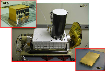
The CRISM instrument consists of:
-
The Optical Sensor Unit (OSU), which includes the optics, a gimbal to remove smear due to spacecraft motion, two detectors for visible and infrared images, cryocoolers to cool the infrared detectors, radiators to keep the instrument cold, and electronics.
-
The Gimbal Motor Electronics (GME), which commands and powers the gimbal and analyzes data from its angular position encoder in a feedback loop
-
The Data Processing Unit (DPU), which accepts and processes commands from the spacecraft and data from the OSU to communicate it to the spacecraft
5. India’s Mars Orbiter Mission (MOM).

Another photo of MOM – Mars Orbiter Mission (India) (below)

6. Mars Express by ESA (European Space Agency)
